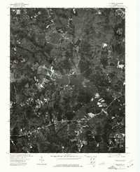
1974 Map of Hallsboro
USGS Topo · Published 1977About this map
Swift Creek Reservoir dominates this 1974 orthophotoquad, showing the intricate shoreline and surrounding wooded terrain of Chesterfield County during a period of significant regional transition. This photographic survey, produced by the U.S. Geological Survey in cooperation with the Virginia Division of Mineral Resources, provides a rare top-down visual record of the land before modern suburban expansion fully reshaped the area. The small settlement of Hallsboro is visible in the northwestern portion of the map, appearing as a cluster of structures amidst a patchwork of forest and clearings. The high-contrast imagery captures the exact footprint of early roads and rural properties, offering a precise grounding for researchers tracing the historical development of the Swift Creek watershed and the rural outskirts of Richmond.
Find a feature on this map
2 named features on this map. Tap any name to fly to it.
Don’t see what you’re looking for? This feature index may not catch every label — zoom into the map to look around manually.
Map Details
Editions of this 1974 Hallsboro Map
This is the sole edition of this map. No revisions or reprints were ever made.
Other maps of this area

1890 · Goochland
USGS Topo · 1:125,000

1892 · Goochland
USGS Topo · 1:125,000

1897 · Amelia
USGS Topo · 1:125,000

1936 · Richmond West
USGS Topo · 1:24,000

1942 · Westhampton
USGS Topo · 1:31,680

1943 · Fine Creek Mills
USGS Topo · 1:31,680

1943 · Chesterfield
USGS Topo · 1:31,680

1943 · Goodes Bridge
USGS Topo · 1:31,680

1943 · Hallsboro
USGS Topo · 1:31,680

1943 · Beach
USGS Topo · 1:24,000