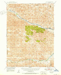
1950 Map of Halsey
USGS Topo · Published 1950About this map
The Middle Loup River and Dismal River carve through the characteristic Sandhills topography of the Thomas and Blaine County line. Centered on the Nebraska National Forest, this 1950 edition shows the early development of the Bessey Ranger District, including the Nursery and the elevated vantage point of Scott Lookout Tower. The settlement of Halsey sits on the riverbanks, serving as a key point on the Chicago Burlington and Quincy railroad line that follows the water's path northwest through Natick. Beyond the forest boundary, the landscape is dotted with numerous Windmill sites, indicating the critical role of groundwater for cattle ranching in this arid grassland. Education in these rural stretches is anchored by the Rose Hill Sch, situated in the northern reaches of the quadrangle.
Find a feature on this map
13 named features on this map. Tap any name to fly to it.
Don’t see what you’re looking for? This feature index may not catch every label — zoom into the map to look around manually.
Map Details
Editions of this 1950 Halsey Map
2 editions found

Other maps of this area

1948 · Thedford
USGS Topo · 1:62,500

1948 · Linscott
USGS Topo · 1:62,500

1948 · Halsey
USGS Topo · 1:62,500

1948 · Seneca 4
USGS Topo · 1:62,500

1949 · Seneca 4
USGS Topo · 1:62,500

1949 · Purdum
USGS Topo · 1:62,500

1949 · Cody Lake
USGS Topo · 1:62,500

1949 · Koshopah
USGS Topo · 1:62,500

1950 · Linscott
USGS Topo · 1:62,500

1950 · Thedford
USGS Topo · 1:62,500