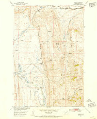
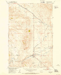
1951 Map of Hamen
USGS Topo · Published 1953About this map
Loweth and the whistle-stop of Hamen anchor this mid-century portrait of Meagher County's ranching country, where the Chicago Milwaukee St Paul and Pacific railroad traces the northern divide. The landscape is defined by its water management and high-altitude grazing, featuring the Hamen Reservoir and Higgins Reservoir alongside a network of ditches and creeks like Sixteenmile Creek. This 1951 field survey records a moment when the regional population was shifting, noted by the many legacy holdings such as the Green Ranch and Brekke Ranch marked as abandoned.
Find a feature on this map
37 named features on this map. Tap any name to fly to it.
Don’t see what you’re looking for? This feature index may not catch every label — zoom into the map to look around manually.
Map Details
Editions of this 1951 Hamen Map
4 editions found
Other maps of this area

1886 · Little Belt Mts.
USGS Topo · 1:250,000

1894 · Little Belt Mts.
USGS Topo · 1:250,000

1897 · Little Belt Mts.
USGS Topo · 1:250,000

1898 · Little Belt Mts.
USGS Topo · 1:250,000

1902 · Little Belt Mts.
USGS Topo · 1:250,000

1948 · White Sulphur Springs
USGS Topo · 1:250,000

1951 · Sixteen NE
USGS Topo · 1:24,000

1951 · Hamen
USGS Topo · 1:24,000
1951 · Wolf Hill
USGS Topo · 1:24,000
1951 · Ringling
USGS Topo · 1:24,000