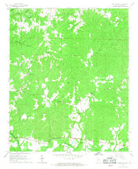
1967 Map of Hamilton NE
USGS Topo · Published 1968About this map
The Buttahatchee River winds through the southern landscape of this Marion County quadrangle, defining the local geography alongside numerous rural landmarks. The settlement of Clifty sits in the northwest, while the countryside is dotted with foundational community institutions such as Southern Schoolhouse Ch and Buttahatchee Sch. The era's economic activity is visible through scattered Claypits and several Gravel Pits, alongside water-powered history at Tyre Mill Pond. Genealogists will find a high concentration of burial grounds and rural congregations, including the Union Hill Cem, Weatherly Cem, Burleson Cem, and Old Bethel Ch. A Gaging Station on the river and the complex network of creeks like Barn Creek and Little Camp Creek illustrate the importance of water management and natural drainage in this part of northwestern Alabama during the mid-1960s.
Find a feature on this map
38 named features on this map. Tap any name to fly to it.
Don’t see what you’re looking for? This feature index may not catch every label — zoom into the map to look around manually.
Map Details
Editions of this 1967 Hamilton NE Map
2 editions found
Other maps of this area

1936 · Hodges
USGS Topo · 1:24,000

1936 · Phil Campbell
USGS Topo · 1:24,000

1936 · South Of Hackleburg
USGS Topo · 1:24,000

1936 · Hackleburg
USGS Topo · 1:24,000

1936 · Goddard
USGS Topo · 1:24,000

1946 · Hackleburg
USGS Topo · 1:24,000

1946 · Phil Campbell
USGS Topo · 1:24,000

1947 · Phil Campbell
USGS Topo · 1:24,000
1948 · Hackleburg
USGS Topo · 1:24,000

1949 · Hodges
USGS Topo · 1:24,000