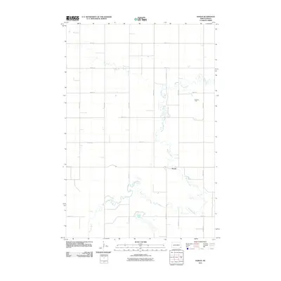
2011 Map of Hamlin
USGS Topo · Published 2011About this map
The Wild Rice River winds through this Richland County landscape, defining the character of Dexter Township. At the center of this hydrographic network is Hamlin, a small settlement positioned near a significant bend in the river. This region of North Dakota is characterized by a precise grid of rural roads and avenues, such as 81st St SE and 145th Ave SE, which facilitate the agricultural economy of the Red River Valley. Notable landmarks include Berre Lake to the south and Erickson Field in the northeast, highlighting the local importance of specific water bodies and airstrips in this prairie environment. The proximity of County Hwy 14 provides a primary north-south artery through the heart of the township.
Find a feature on this map
20 named features on this map. Tap any name to fly to it.
Don’t see what you’re looking for? This feature index may not catch every label — zoom into the map to look around manually.
Map Details
Editions of this 2011 Hamlin Map
This is the sole edition of this map. No revisions or reprints were ever made.
Other maps of this area

1907 · Wyndmere
USGS Topo · 1:125,000

1953 · Fargo
USGS Topo · 1:250,000

1956 · Fargo
USGS Topo · 1:250,000

1958 · Cayuga NW
USGS Topo · 1:24,000

1958 · Hamlin
USGS Topo · 1:24,000

1958 · Geneseo
USGS Topo · 1:24,000
1958 · Cayuga
USGS Topo · 1:24,000

1960 · Wyndmere
USGS Topo · 1:24,000

1960 · De Lamere
USGS Topo · 1:24,000

1960 · Milnor
USGS Topo · 1:24,000