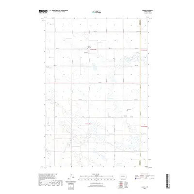
2020 Map of Hamlin
USGS Topo · Published 2020About this map
Hamlin serves as a central point of settlement within this rural landscape, situated near the boundary between Sargent Co and Richland Co. The terrain is defined by the winding course of the Wild Rice River, which meanders through a prairie environment marked by numerous small wetlands and basins. This area is characterized by a strong historical religious presence, evidenced by the multiple burial grounds including the Immanuel Lutheran Church Cem, Immanuel South Cem, and the Hamlin Cem. The road network follows a strict section-line grid, typical of the Great Plains' development, with primary local routes like Co Rd 1 and Co Rd 14 connecting scattered farmsteads. Natural water features such as Berre Lake and Murach Lake provide distinct landmarks amidst the agricultural fields.
Find a feature on this map
30 named features on this map. Tap any name to fly to it.
Don’t see what you’re looking for? This feature index may not catch every label — zoom into the map to look around manually.
Map Details
Editions of this 2020 Hamlin Map
This is the sole edition of this map. No revisions or reprints were ever made.
Other maps of this area

1907 · Wyndmere
USGS Topo · 1:125,000

1953 · Fargo
USGS Topo · 1:250,000

1956 · Fargo
USGS Topo · 1:250,000

1958 · Cayuga NW
USGS Topo · 1:24,000

1958 · Hamlin
USGS Topo · 1:24,000

1958 · Geneseo
USGS Topo · 1:24,000
1958 · Cayuga
USGS Topo · 1:24,000

1960 · Wyndmere
USGS Topo · 1:24,000

1960 · De Lamere
USGS Topo · 1:24,000

1960 · Milnor
USGS Topo · 1:24,000