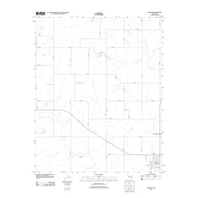
2012 Map of Hammon
USGS Topo · Published 2012About this map
The town of Hammon serves as the primary hub in this portion of Roger Mills County, situated along the southern bend of the Washita River. This modern survey reveals a highly organized section-line road network typical of the Oklahoma prairie, where routes like n2000 RD and e0910 RD facilitate movement across the agricultural landscape. Just north of town lies Hammon Junction, a point of interest for those tracking local transportation history. The terrain is defined by numerous watercourses that feed the river system, including the meandering Ninemile Cr in the west and Quartermaster Cr in the northeast. For genealogists and local historians, the Barker Cem remains a significant landmark north of the river, while the street grid of Hammon—including Main ST and Broadway—is clearly delineated at the southern edge of the sheet.
Find a feature on this map
39 named features on this map. Tap any name to fly to it.
Don’t see what you’re looking for? This feature index may not catch every label — zoom into the map to look around manually.
Map Details
Editions of this 2012 Hammon Map
This is the sole edition of this map. No revisions or reprints were ever made.
Other maps of this area

1955 · Clinton
USGS Topo · 1:250,000

1957 · Clinton
USGS Topo · 1:250,000

1960 · Cheyenne
USGS Topo · 1:62,500

1960 · Hammon
USGS Topo · 1:62,500

1961 · Leedey
USGS Topo · 1:62,500

1966 · Roll SE
USGS Topo · 1:24,000

1984 · Foss Reservoir
USGS Topo · 1:100,000
1987 · Leedey SW
USGS Topo · 1:24,000

1987 · Big Kiowa Creek
USGS Topo · 1:24,000
1987 · Leedey
USGS Topo · 1:24,000