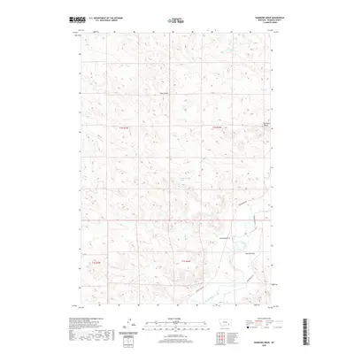
2020 Map of Hammond Draw
USGS Topo · Published 2020About this map
The Tongue River meanders through the southeastern corner of this Rosebud County landscape, serving as a primary hydrological anchor for the surrounding high plains. The terrain is defined by a series of significant drainage systems and topographical markers, including the prominent Trembling Butte to the east and the namesake Hammond Draw. These natural features dictated the placement of local infrastructure, notably Tongue River Rd and Brandenberg Rd, which track the contours of the river valley. Numerous seasonal watercourses such as Sand Coulee, Joe Leg Cr, and Roe and Cooper Cr carve out a complex network of coulees and draws. This modern survey also documents isolated water sources like the 01N44E30BDCA01 Spring, essential in this semi-arid ranching environment where water access defines land utility.
Find a feature on this map
17 named features on this map. Tap any name to fly to it.
Don’t see what you’re looking for? This feature index may not catch every label — zoom into the map to look around manually.
Map Details
Editions of this 2020 Hammond Draw Map
This is the sole edition of this map. No revisions or reprints were ever made.
Other maps of this area

1954 · Hardin
USGS Topo · 1:250,000

1957 · Hardin
USGS Topo · 1:250,000

1958 · Hardin
USGS Topo · 1:250,000

1958 · Garfield Peak
USGS Topo · 1:24,000

1966 · Cook Creek Reservoir
USGS Topo · 1:24,000

1966 · Ashland NE
USGS Topo · 1:24,000
1971 · Brandenberg NW
USGS Topo · 1:24,000

1971 · Hammond Draw NW
USGS Topo · 1:24,000

1971 · Hammond Draw
USGS Topo · 1:24,000
1971 · Hammond Draw SW
USGS Topo · 1:24,000