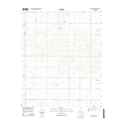
2013 Map of Hammond Ranch
USGS Topo · Published 2013About this map
Roach Cem sits on the western edge of this High Plains landscape, a notable landmark for local genealogists studying the borderlands of the Llano Estacado. The area is defined by a grid of rural routes including Quay Road AB and Co Road 28, which service several established agricultural properties such as Hammond Ranch and Williams Ranch. The topography is relatively level except where it is interrupted by the natural drainage of Frio Draw in the east, which creates subtle variations in the terrain. The map captures a late-twentieth-century transition into the digital era of surveying, showing how the historic township and range system—marked here as t6n r33e and t5n r33e—continues to dictate the layout of modern ranching boundaries and state roads like NM-288.
Find a feature on this map
28 named features on this map. Tap any name to fly to it.
Don’t see what you’re looking for? This feature index may not catch every label — zoom into the map to look around manually.
Map Details
Editions of this 2013 Hammond Ranch Map
This is the sole edition of this map. No revisions or reprints were ever made.
Other maps of this area

1954 · Clovis
USGS Topo · 1:250,000

1957 · Hammond Ranch
USGS Topo · 1:62,500

1958 · Clovis
USGS Topo · 1:250,000

1971 · Grady
USGS Topo · 1:24,000

1971 · Grady SW
USGS Topo · 1:24,000

1971 · Forrest
USGS Topo · 1:24,000

1973 · Field SE
USGS Topo · 1:24,000
1973 · Field
USGS Topo · 1:24,000

1985 · Smith Ranch
USGS Topo · 1:24,000
1985 · Garrett Ranch
USGS Topo · 1:24,000