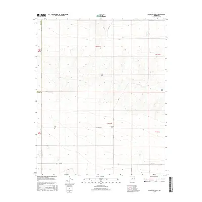
2017 Map of Hammond Ranch
USGS Topo · Published 2017About this map
The High Plains of Eastern New Mexico are defined here by the gentle depressions and drainage paths of Frio Draw, which meanders across this rural Curry County landscape. The survey captures a sparsely populated ranching region north of Clovis, where the land is organized into a rigid grid of county roads. The namesake Hammond Ranch serves as a central landmark in this agricultural expanse, situated near the intersection of Co Rd W and Curry Road 28. A significant site for local family historians is the Roach Cem, located in the western portion of the quadrangle along Curry Road AB. This 2017 edition illustrates the modern infrastructure of the Llano Estacado, including the border between Quay Co and Curry Co at the northern edge of the map.
Find a feature on this map
26 named features on this map. Tap any name to fly to it.
Don’t see what you’re looking for? This feature index may not catch every label — zoom into the map to look around manually.
Map Details
Editions of this 2017 Hammond Ranch Map
This is the sole edition of this map. No revisions or reprints were ever made.
Other maps of this area

1954 · Clovis
USGS Topo · 1:250,000

1957 · Hammond Ranch
USGS Topo · 1:62,500

1958 · Clovis
USGS Topo · 1:250,000

1971 · Grady
USGS Topo · 1:24,000

1971 · Grady SW
USGS Topo · 1:24,000

1971 · Forrest
USGS Topo · 1:24,000

1973 · Field SE
USGS Topo · 1:24,000
1973 · Field
USGS Topo · 1:24,000

1985 · Smith Ranch
USGS Topo · 1:24,000
1985 · Garrett Ranch
USGS Topo · 1:24,000