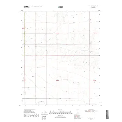
2020 Map of Hammond Ranch
USGS Topo · Published 2020About this map
Frio Draw cuts a significant west-to-east path across this high plains landscape of eastern New Mexico. The area is characterized by large-scale agricultural and ranching operations, with the namesake Hammond Ranch serving as a primary local landmark. A notable historical site is the Roach Cem, located just off Curry Road 28, which provides a tangible link to the early families who settled this part of the Llano Estacado. The map also delineates the jurisdictional boundary between Quay County and Curry County at its western edge. A precise grid of county roads, such as Curry Road 34 and Co Rd 26, reveals the enduring structure of the Public Land Survey System that organized this territory into townships and sections.
Find a feature on this map
19 named features on this map. Tap any name to fly to it.
Don’t see what you’re looking for? This feature index may not catch every label — zoom into the map to look around manually.
Map Details
Editions of this 2020 Hammond Ranch Map
This is the sole edition of this map. No revisions or reprints were ever made.
Other maps of this area

1954 · Clovis
USGS Topo · 1:250,000

1957 · Hammond Ranch
USGS Topo · 1:62,500

1958 · Clovis
USGS Topo · 1:250,000

1971 · Grady
USGS Topo · 1:24,000

1971 · Grady SW
USGS Topo · 1:24,000

1971 · Forrest
USGS Topo · 1:24,000

1973 · Field SE
USGS Topo · 1:24,000
1973 · Field
USGS Topo · 1:24,000

1985 · Smith Ranch
USGS Topo · 1:24,000
1985 · Garrett Ranch
USGS Topo · 1:24,000