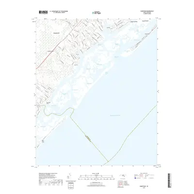
2019 Map of Hampstead
USGS Topo · Published 2019About this map
Hampstead and the neighboring community of Brown Town anchor the mainland portion of this coastal survey, where the residential footprint extends toward the Intracoastal Waterway. The landscape is defined by the complex barrier island system of Topsail Island and Figure Eight Island, separated from the mainland by a labyrinth of tidal channels and sounds. Significant maritime passages like New Topsail Inlet and Rich Inlet illustrate the dynamic nature of the Atlantic coastline, where Banks Channel and Topsail Sound provide sheltered waters behind the primary dunes. The map captures the modern development of coastal retreats such as Topsail Beach, alongside older geographic points like Old Point and Kings Landing. Numerous named channels, including Howards Channel and Black Mud Channel, trace the navigable routes through the salt marshes, reflecting the area's deep-seated connection to the sea and the coastal waterway trade.
Find a feature on this map
85 named features on this map. Tap any name to fly to it.
Don’t see what you’re looking for? This feature index may not catch every label — zoom into the map to look around manually.
Map Details
Editions of this 2019 Hampstead Map
This is the sole edition of this map. No revisions or reprints were ever made.
Other maps of this area

1942 · Topsail
USGS Topo · 1:62,500

1942 · Wilmington
USGS Topo · 1:62,500

1947 · Rocky Point
USGS Topo · 1:62,500

1948 · Topsail
USGS Topo · 1:62,500

1948 · Wilmington
USGS Topo · 1:62,500

1953 · Beaufort
USGS Topo · 1:250,000

1954 · Beaufort
USGS Topo · 1:250,000

1970 · Hampstead
USGS Topo · 1:24,000
1970 · Wrightsville Beach
USGS Topo · 1:24,000

1970 · Topsail
USGS Topo · 1:24,000