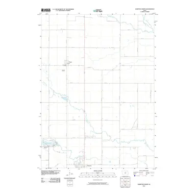
2010 Map of Hampton North
USGS Topo · Published 2010About this map
Hampton and the village of Chapin anchor this North Central Iowa landscape, where the rectangular survey grid of the rural township meets the meandering paths of regional waterways. The northern outskirts of Hampton are defined by the convergence of Spring Creek and Squaw Creek, while the northwestern corner of the area features Beeds Lake and the adjacent Beeds Lake Airport. This 2010 survey illustrates a quintessential Midwestern agricultural pattern, with a dense network of numbered roads such as 240th St and named thoroughfares like Nettle Ave and Raven Ave that segment the prairie.
Find a feature on this map
37 named features on this map. Tap any name to fly to it.
Don’t see what you’re looking for? This feature index may not catch every label — zoom into the map to look around manually.
Map Details
Editions of this 2010 Hampton North Map
This is the sole edition of this map. No revisions or reprints were ever made.
Other maps of this area

1954 · Waterloo
USGS Topo · 1:250,000

1955 · Waterloo
USGS Topo · 1:250,000

1972 · Hansell
USGS Topo · 1:24,000
1972 · Dougherty
USGS Topo · 1:24,000

1972 · Swaledale
USGS Topo · 1:24,000
1972 · Sheffield
USGS Topo · 1:24,000

1972 · Latimer
USGS Topo · 1:24,000

1972 · Hampton North
USGS Topo · 1:24,000

1979 · Ackley NE
USGS Topo · 1:24,000

1979 · Coulter
USGS Topo · 1:24,000