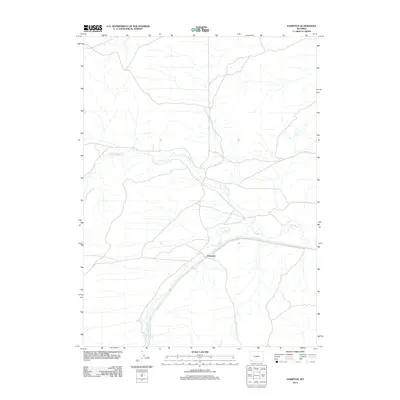
2012 Map of Hampton
USGS Topo · Published 2012About this map
Hampton stands at a transition point in the high plains of Uinta County, where the transportation corridor follows the natural drainage of the region. The landscape is defined by the meandering course of Muddy Creek and its tributary, Little Muddy Creek, which cut through the arid terrain. These waterways have historically dictated the placement of roads and early settlement patterns in this part of Wyoming, providing essential water sources in an otherwise dry environment. The 2012 survey illustrates how modern infrastructure continues to parallel these ancient geographic features, maintaining the same path through the basin that travelers have used for generations.
Find a feature on this map
3 named features on this map. Tap any name to fly to it.
Don’t see what you’re looking for? This feature index may not catch every label — zoom into the map to look around manually.
Map Details
Editions of this 2012 Hampton Map
This is the sole edition of this map. No revisions or reprints were ever made.
Other maps of this area

1954 · Ogden
USGS Topo · 1:250,000

1958 · Ogden
USGS Topo · 1:250,000

1960 · Ogden
USGS Topo · 1:250,000

1964 · Carter
USGS Topo · 1:24,000

1964 · Austin Reservoir
USGS Topo · 1:24,000
1965 · Millersville
USGS Topo · 1:24,000

1969 · Church Butte NW
USGS Topo · 1:24,000

1969 · Roberson Creek
USGS Topo · 1:24,000

1969 · Hampton
USGS Topo · 1:24,000
1969 · Church Butte
USGS Topo · 1:24,000