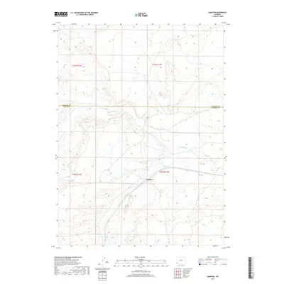
2017 Map of Hampton
USGS Topo · Published 2017About this map
Hampton occupies a central position in this high-plains landscape, where the confluence of Muddy Cr and Little Muddy Cr defines the local topography. This 2017 survey shows the intricate drainage patterns of the high desert, with the streams winding through wide valleys between modest ridges. The map clearly delineates the administrative boundary between Lincoln Co and Uinta Co, running east to west through the northern half of the quadrangle. As a modern topographic record, it utilizes data from the National Elevation Dataset and GNIS to document the sparse settlement patterns and the enduring watercourses that have historically dictated the placement of roads and homesteads in this part of southwestern Wyoming.
Find a feature on this map
8 named features on this map. Tap any name to fly to it.
Don’t see what you’re looking for? This feature index may not catch every label — zoom into the map to look around manually.
Map Details
Editions of this 2017 Hampton Map
This is the sole edition of this map. No revisions or reprints were ever made.
Other maps of this area

1954 · Ogden
USGS Topo · 1:250,000

1958 · Ogden
USGS Topo · 1:250,000

1960 · Ogden
USGS Topo · 1:250,000

1964 · Carter
USGS Topo · 1:24,000

1964 · Austin Reservoir
USGS Topo · 1:24,000
1965 · Millersville
USGS Topo · 1:24,000

1969 · Church Butte NW
USGS Topo · 1:24,000

1969 · Roberson Creek
USGS Topo · 1:24,000

1969 · Hampton
USGS Topo · 1:24,000
1969 · Church Butte
USGS Topo · 1:24,000