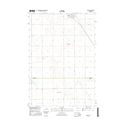
2016 Map of Hancock
USGS Topo · Published 2016About this map
Hancock sits at the northern edge of this prairie landscape, organized around a grid of streets including Pacific Ave and Atlantic Ave. The town’s position along the rail corridor is reflected in its layout, with the Old Hwy 9 Twp Rd paralleling the tracks toward the southeast. Beyond the residential center, the terrain is defined by an extensive network of drainage and agricultural management, most notably the Judicial Ditch Number Nine which cuts through the southern sections. This 2016 survey captures the transition between the developed hub of Hancock and the surrounding rural stretches of Stevens and Swift counties. To the west, Byrne Lake provides a natural landmark amidst the section lines of the township grid, while a rigorous system of county roads, such as Co Hwy 8 and Co Hwy 1, facilitates travel across the agricultural heartland.
Find a feature on this map
24 named features on this map. Tap any name to fly to it.
Don’t see what you’re looking for? This feature index may not catch every label — zoom into the map to look around manually.
Map Details
Editions of this 2016 Hancock Map
This is the sole edition of this map. No revisions or reprints were ever made.
Other maps of this area

1912 · Morris
USGS Topo · 1:62,500

1953 · Saint Cloud
USGS Topo · 1:250,000

1957 · Saint Cloud
USGS Topo · 1:250,000

1958 · Saint Cloud
USGS Topo · 1:250,000

1968 · Cyrus
USGS Topo · 1:24,000

1968 · Danvers
USGS Topo · 1:24,000

1968 · Hancock
USGS Topo · 1:24,000
1968 · Hancock SW
USGS Topo · 1:24,000
1968 · Clontarf North
USGS Topo · 1:24,000
1968 · Hancock NW
USGS Topo · 1:24,000