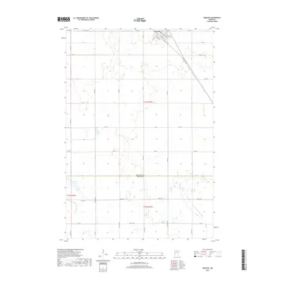
2019 Map of Hancock
USGS Topo · Published 2019About this map
Hancock serves as the primary municipal center on this 2019 survey, situated at the junction of several established thoroughfares including Atlantic Ave, Pacific Ave, and Jefferson Ave. The surrounding landscape is defined by its agricultural and drainage history, visible through the extensive network of township roads and significant water management features like Judicial Ditch Number Sixtythree and Judicial Ditch Number Nine. The boundary between Stevens Co and Swift Co cuts through the southern portion of the quadrangle, reflecting the administrative divisions of this prairie region. Notable water bodies like Byrne Lake provide geographic orientation within the grid of section lines and township roads such as Old Hwy 9 Twp Rd, which traces a diagonal path across the northern townships.
Find a feature on this map
29 named features on this map. Tap any name to fly to it.
Don’t see what you’re looking for? This feature index may not catch every label — zoom into the map to look around manually.
Map Details
Editions of this 2019 Hancock Map
This is the sole edition of this map. No revisions or reprints were ever made.
Other maps of this area

1912 · Morris
USGS Topo · 1:62,500

1953 · Saint Cloud
USGS Topo · 1:250,000

1957 · Saint Cloud
USGS Topo · 1:250,000

1958 · Saint Cloud
USGS Topo · 1:250,000

1968 · Cyrus
USGS Topo · 1:24,000

1968 · Danvers
USGS Topo · 1:24,000

1968 · Hancock
USGS Topo · 1:24,000
1968 · Hancock SW
USGS Topo · 1:24,000
1968 · Clontarf North
USGS Topo · 1:24,000
1968 · Hancock NW
USGS Topo · 1:24,000