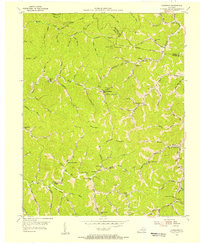
1954 Map of Handshoe
USGS Topo · Published 1956About this map
Quicksand Creek winds through the heart of this East Kentucky landscape, where the confluence of numerous branches once defined the social and economic reach of local hollows. During the mid-1950s, the area's rural infrastructure was characterized by a dense network of mountain schools, including Upper Quicksand Sch and Ball Branch Sch, and isolated settlements like Handshoe and Bolyn. The map captures a moment when topography dictated the location of vital community centers, such as Saltlick Ch and the Signal Knob Lookout Tower, which monitored the expansive timberlands of the surrounding Yellow Mountain and Chestnut Mountain. This survey was compiled using aerial photography and specialized coal company maps, reflecting the industrial interests that shared this geography with the subsistence-based homesteads found along Saltlick Creek and Balls Fork.
Find a feature on this map
78 named features on this map. Tap any name to fly to it.
Don’t see what you’re looking for? This feature index may not catch every label — zoom into the map to look around manually.
Map Details
Editions of this 1954 Handshoe Map
Other maps of this area

1886 · Prestonsburg
USGS Topo · 1:125,000

1889 · Salyersville
USGS Topo · 1:125,000

1890 · Whitesburg
USGS Topo · 1:125,000

1891 · Hazard
USGS Topo · 1:125,000

1891 · Salyersville
USGS Topo · 1:125,000

1892 · Whitesburg
USGS Topo · 1:125,000

1892 · Prestonsburg
USGS Topo · 1:125,000

1899 · Salyersville
USGS Topo · 1:125,000

1912 · Hindman
USGS Topo · 1:48,000

1914 · Troublesome
USGS Topo · 1:62,500