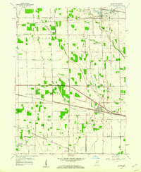
1958 Map of Hanna
USGS Topo · Published 1960About this map
Hanna stands as a primary rail junction in the late 1950s, where the Pennsylvania and Chesapeake and Ohio lines intersect amidst a landscape dominated by drainage engineering. The township boundaries of Clinton, Noble, Cass, and Hanna are clearly delineated, reflecting a rural order defined by the cardinal-direction grid of roads like 800 South Road and 1200 South Road. This agrarian territory is heavily modified by an extensive network of ditches and arms, including Grand Trunk Arm and Ohio Ditch, essential for managing the low-lying terrain. To the north, Union Mills and Wellsboro anchor the community, while the Lincoln Highway provides a major east-west artery through the center of the sheet. Local genealogy interest is found in the scattered rural landmarks such as Township School and churches like Zion Ch and St Johns Ch in the southwestern corner.
Find a feature on this map
49 named features on this map. Tap any name to fly to it.
Don’t see what you’re looking for? This feature index may not catch every label — zoom into the map to look around manually.
Map Details
Editions of this 1958 Hanna Map
2 editions found
Other maps of this area

1953 · Wanatah
USGS Topo · 1:24,000

1953 · Westville
USGS Topo · 1:24,000

1953 · Chicago
USGS Topo · 1:250,000

1957 · Chicago
USGS Topo · 1:250,000

1957 · Knox West
USGS Topo · 1:24,000

1958 · La Crosse
USGS Topo · 1:24,000

1958 · Hanna
USGS Topo · 1:24,000

1958 · Kingsford Heights
USGS Topo · 1:24,000

1958 · La Porte East
USGS Topo · 1:24,000

1959 · English Lake
USGS Topo · 1:24,000