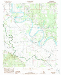
1989 Map of Hanna
USGS Topo · Published 1989About this map
The Red River winds through this Louisiana landscape, defining the convergence of Red River, Natchitoches, and De Soto Parishes in the late 20th century. The intricate hydrography of the region is evident in the numerous oxbow lakes and bypasses, such as Bull Lake, Boggy Lake, and Old Lake, which flank the main river channel. Settlement patterns are largely dictated by this riparian geography, with communities like Hanna and Redoak situated near the water's edge.
Find a feature on this map
38 named features on this map. Tap any name to fly to it.
Don’t see what you’re looking for? This feature index may not catch every label — zoom into the map to look around manually.
Map Details
Editions of this 1989 Hanna Map
2 editions found
Other maps of this area

1937 · Campti NW
USGS Topo · 1:31,680

1937 · Campti SW
USGS Topo · 1:31,680

1938 · Chemard Lake
USGS Topo · 1:31,680

1938 · Hollis Creek
USGS Topo · 1:31,680

1938 · Allen
USGS Topo · 1:31,680

1938 · Lake End
USGS Topo · 1:31,680

1944 · Campti
USGS Topo · 1:62,500

1947 · Ashland
USGS Topo · 1:62,500

1947 · Hanna
USGS Topo · 1:62,500

1948 · Coushatta
USGS Topo · 1:62,500