
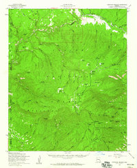
1958 Map of Hannagan Meadow
USGS Topo · Published 1963About this map
Mogollon Rim anchors this high-elevation survey of the Apache National Forest, where steep canyons and high points define the landscape of eastern Arizona. The Coronado Trail winds through the eastern half of the sheet, providing access to remote outposts like Sprucedale and seasonal sites such as the Hannagan Meadow Campground. This era represents a period of active fire surveillance and forest management, evidenced by Reno Lookout and Blue Lookout standing watch over the drainages of the Black River. Numerous wetlands known as cienegas, including KP Cienega and Butterfly Cienega, suggest a complex hydrology where high-country meadows collected snowmelt and spring water for the surrounding livestock and wildlife. Foot and horse travel are well-documented through the Hannagan Trail and Warren Trail, connecting various backcountry draws and peaks.
Find a feature on this map
83 named features on this map. Tap any name to fly to it.
Don’t see what you’re looking for? This feature index may not catch every label — zoom into the map to look around manually.
Map Details
Editions of this 1958 Hannagan Meadow Map
2 editions found
Historical Maps of Cleaveland Through Time
173 maps found
1958 Hannagan Meadow
Greenlee County, AZ

1959 York Valley
Greenlee County, AZ

1961 Blue
Greenlee County, AZ

1962 Big Lue Mts
Greenlee County, AZ

1967 Alma Mesa
Greenlee County, AZ

1967 Bee Canyon
Greenlee County, AZ

1967 Dutch Blue Creek
Greenlee County, AZ

1967 Fritz Canyon
Greenlee County, AZ

1967 Maple Peak
Greenlee County, AZ

1967 Pipestem Mountain
Greenlee County, AZ

1967 Robinson Mesa
Greenlee County, AZ

1967 Rose Peak
Greenlee County, AZ

1986 Guthrie
Greenlee County, AZ

1986 Hot Well
Greenlee County, AZ

1986 Round Mountain
Greenlee County, AZ

1986 Sheldon
Greenlee County, AZ

1986 Whitlock Peak
Greenlee County, AZ

1989 Big Lue Mountains
Greenlee County, AZ

1989 Copperplate Gulch
Greenlee County, AZ

1989 Coronado Mountain
Greenlee County, AZ

1989 Dix Creek
Greenlee County, AZ

1989 Mitchell Peak
Greenlee County, AZ

1989 Rattlesnake Spring
Greenlee County, AZ

1991 Baldy Bill Point
Greenlee County, AZ

1991 Bear Mountain
Greenlee County, AZ

1991 Beaverhead
Greenlee County, AZ

1991 Blue
Greenlee County, AZ

1991 Hannagan Meadow
Greenlee County, AZ

1991 Hoodoo Knoll
Greenlee County, AZ

1991 Maness Peak
Greenlee County, AZ

1991 Strayhorse
Greenlee County, AZ

1997 Alma Mesa
Greenlee County, AZ

1997 Baldy Bill Point
Greenlee County, AZ

1997 Bear Mountain
Greenlee County, AZ

1997 Beaverhead
Greenlee County, AZ

1997 Bee Canyon
Greenlee County, AZ

1997 Big Lue Mountains
Greenlee County, AZ

1997 Blue
Greenlee County, AZ

1997 Copperplate Gulch
Greenlee County, AZ

1997 Coronado Mountain
Greenlee County, AZ

1997 Dix Creek
Greenlee County, AZ

1997 Dutch Blue Creek
Greenlee County, AZ

1997 Fritz Canyon
Greenlee County, AZ

1997 Hannagan Meadow
Greenlee County, AZ

1997 Hoodoo Knoll
Greenlee County, AZ

1997 Maness Peak
Greenlee County, AZ

1997 Maple Peak
Greenlee County, AZ

1997 Mitchell Peak
Greenlee County, AZ

1997 Pipestem Mountain
Greenlee County, AZ

1997 Rattlesnake Spring
Greenlee County, AZ

1997 Robinson Mesa
Greenlee County, AZ

1997 Rose Peak
Greenlee County, AZ

1997 Strayhorse
Greenlee County, AZ

2005 Alma Mesa
Greenlee County, AZ

2005 Big Lue Mountains
Greenlee County, AZ

2005 Blue
Greenlee County, AZ

2005 Maness Peak
Greenlee County, AZ

2005 Maple Peak
Greenlee County, AZ

2010 Round Mountain
Greenlee County, AZ

2011 Alma Mesa
Greenlee County, AZ

2011 Baldy Bill Point
Greenlee County, AZ

2011 Bear Mountain
Greenlee County, AZ

2011 Beaverhead
Greenlee County, AZ

2011 Bee Canyon
Greenlee County, AZ

2011 Big Lue Mountains
Greenlee County, AZ

2011 Blue
Greenlee County, AZ

2011 Copperplate Gulch
Greenlee County, AZ

2011 Coronado Mountain
Greenlee County, AZ

2011 Dix Creek
Greenlee County, AZ

2011 Dutch Blue Creek
Greenlee County, AZ

2011 Fritz Canyon
Greenlee County, AZ

2011 Guthrie
Greenlee County, AZ

2011 Hannagan Meadow
Greenlee County, AZ

2011 Hoodoo Knoll
Greenlee County, AZ

2011 Hot Well
Greenlee County, AZ

2011 Maness Peak
Greenlee County, AZ

2011 Maple Peak
Greenlee County, AZ

2011 Mitchell Peak
Greenlee County, AZ

2011 Pipestem Mountain
Greenlee County, AZ

2011 Rattlesnake Spring
Greenlee County, AZ

2011 Robinson Mesa
Greenlee County, AZ

2011 Rose Peak
Greenlee County, AZ

2011 Round Mountain
Greenlee County, AZ

2011 Sheldon
Greenlee County, AZ

2011 Strayhorse
Greenlee County, AZ

2011 Whitlock Peak
Greenlee County, AZ

2014 Alma Mesa
Greenlee County, AZ

2014 Baldy Bill Point
Greenlee County, AZ

2014 Bear Mountain
Greenlee County, AZ

2014 Beaverhead
Greenlee County, AZ

2014 Bee Canyon
Greenlee County, AZ

2014 Big Lue Mountains
Greenlee County, AZ

2014 Blue
Greenlee County, AZ

2014 Copperplate Gulch
Greenlee County, AZ

2014 Coronado Mountain
Greenlee County, AZ

2014 Dix Creek
Greenlee County, AZ

2014 Dutch Blue Creek
Greenlee County, AZ

2014 Fritz Canyon
Greenlee County, AZ

2014 Guthrie
Greenlee County, AZ

2014 Hannagan Meadow
Greenlee County, AZ

2014 Hoodoo Knoll
Greenlee County, AZ

2014 Hot Well
Greenlee County, AZ

2014 Maness Peak
Greenlee County, AZ

2014 Maple Peak
Greenlee County, AZ

2014 Mitchell Peak
Greenlee County, AZ

2014 Pipestem Mountain
Greenlee County, AZ

2014 Rattlesnake Spring
Greenlee County, AZ

2014 Robinson Mesa
Greenlee County, AZ

2014 Rose Peak
Greenlee County, AZ

2014 Round Mountain
Greenlee County, AZ

2014 Sheldon
Greenlee County, AZ

2014 Strayhorse
Greenlee County, AZ

2014 Whitlock Peak
Greenlee County, AZ

2018 Alma Mesa
Greenlee County, AZ

2018 Baldy Bill Point
Greenlee County, AZ

2018 Bear Mountain
Greenlee County, AZ

2018 Beaverhead
Greenlee County, AZ

2018 Bee Canyon
Greenlee County, AZ

2018 Big Lue Mountains
Greenlee County, AZ

2018 Blue
Greenlee County, AZ

2018 Copperplate Gulch
Greenlee County, AZ

2018 Coronado Mountain
Greenlee County, AZ

2018 Dix Creek
Greenlee County, AZ

2018 Dutch Blue Creek
Greenlee County, AZ

2018 Fritz Canyon
Greenlee County, AZ

2018 Guthrie
Greenlee County, AZ

2018 Hannagan Meadow
Greenlee County, AZ

2018 Hoodoo Knoll
Greenlee County, AZ

2018 Hot Well
Greenlee County, AZ

2018 Maness Peak
Greenlee County, AZ

2018 Maple Peak
Greenlee County, AZ

2018 Mitchell Peak
Greenlee County, AZ

2018 Pipestem Mountain
Greenlee County, AZ

2018 Rattlesnake Spring
Greenlee County, AZ

2018 Robinson Mesa
Greenlee County, AZ

2018 Rose Peak
Greenlee County, AZ

2018 Round Mountain
Greenlee County, AZ

2018 Sheldon
Greenlee County, AZ

2018 Strayhorse
Greenlee County, AZ

2018 Whitlock Peak
Greenlee County, AZ

2021 Alma Mesa
Greenlee County, AZ

2021 Baldy Bill Point
Greenlee County, AZ

2021 Bear Mountain
Greenlee County, AZ

2021 Beaverhead
Greenlee County, AZ

2021 Bee Canyon
Greenlee County, AZ

2021 Big Lue Mountains
Greenlee County, AZ

2021 Blue
Greenlee County, AZ

2021 Copperplate Gulch
Greenlee County, AZ

2021 Coronado Mountain
Greenlee County, AZ

2021 Dix Creek
Greenlee County, AZ

2021 Dutch Blue Creek
Greenlee County, AZ

2021 Fritz Canyon
Greenlee County, AZ

2021 Guthrie
Greenlee County, AZ

2021 Hannagan Meadow
Greenlee County, AZ

2021 Hoodoo Knoll
Greenlee County, AZ

2021 Hot Well
Greenlee County, AZ

2021 Maness Peak
Greenlee County, AZ

2021 Maple Peak
Greenlee County, AZ

2021 Mitchell Peak
Greenlee County, AZ

2021 Pipestem Mountain
Greenlee County, AZ

2021 Rattlesnake Spring
Greenlee County, AZ

2021 Robinson Mesa
Greenlee County, AZ

2021 Rose Peak
Greenlee County, AZ

2021 Round Mountain
Greenlee County, AZ

2021 Sheldon
Greenlee County, AZ

2021 Strayhorse
Greenlee County, AZ

2021 Whitlock Peak
Greenlee County, AZ

2023 Dutch Blue Creek
Greenlee County, AZ

2023 Rose Peak
Greenlee County, AZ

2026 Copperplate Gulch
Greenlee County, AZ

2026 Coronado Mountain
Greenlee County, AZ
2026 Guthrie
Greenlee County, AZ

2026 Maness Peak
Greenlee County, AZ