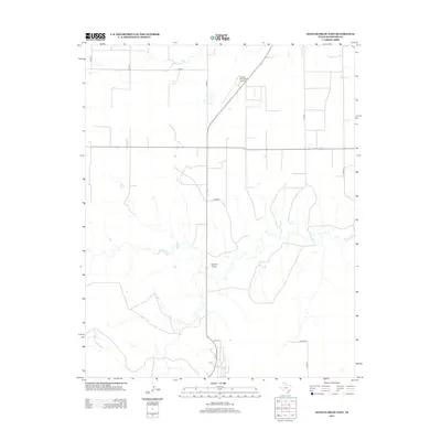
2012 Map of Hannas Draw East
USGS Topo · Published 2012About this map
Hannas Draw meanders through this High Plains landscape, cutting a natural path across the structured grid of the Texas Panhandle. The terrain is defined by its agricultural and aviation utility, with the Gruver Municipal Airport situated in the northern portion of the quadrangle. This 2012 survey illustrates the systematic organization of Hansford County, where a network of numbered and lettered county roads, such as Co Rd 8 and Co Rd S, facilitates movement between large tracts of land. The proximity of Jones Rd to the drainage of the draw indicates how local infrastructure adapts to the area's subtle topography. This map serves as a primary record of the modern rural infrastructure in the vicinity of Gruver, highlighting the intersection of natural drainage systems and human-made transport routes.
Find a feature on this map
10 named features on this map. Tap any name to fly to it.
Don’t see what you’re looking for? This feature index may not catch every label — zoom into the map to look around manually.
Map Details
Editions of this 2012 Hannas Draw East Map
This is the sole edition of this map. No revisions or reprints were ever made.
Other maps of this area

1954 · Perryton
USGS Topo · 1:250,000

1958 · Perryton
USGS Topo · 1:250,000

1962 · Kimball
USGS Topo · 1:24,000

1962 · Hansford
USGS Topo · 1:24,000

1973 · Gruver
USGS Topo · 1:24,000

1974 · Morse
USGS Topo · 1:24,000

1974 · Hannas Draw East
USGS Topo · 1:24,000
1974 · Capps Switch SE
USGS Topo · 1:24,000

1974 · Sunray 1 SE
USGS Topo · 1:24,000

1974 · Hannas Draw West
USGS Topo · 1:24,000