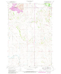
1968 Map of Hannover NE
USGS Topo · Published 1980About this map
Fort Clark Historic Site stands at the Missouri River's edge in this 1968 study, later updated with 1977 aerial revisions. This corner of the Dakotas captures a landscape in transition, where the historical footprint of Fort Clark meets the industrial expansion of the late 20th century. The Burlington Northern line tracks the river valley, serving a region defined by agricultural plots and significant extraction activities. Evidence of the area's geological utility is seen in the Strip Mine and multiple Gravel Pits concentrated near Square Butte Creek. Local lineage is preserved through the Bagley Cem and St Pauls Cem, providing touchpoints for genealogical research. The northern boundary between Mercer and Oliver Counties bisects the upland terrain, including landmarks like Square Butte and the settlement of Alderin.
Find a feature on this map
15 named features on this map. Tap any name to fly to it.
Don’t see what you’re looking for? This feature index may not catch every label — zoom into the map to look around manually.
Map Details
Editions of this 1968 Hannover NE Map
2 editions found
Other maps of this area

1948 · Stanton
USGS Topo · 1:62,500

1949 · Stanton
USGS Topo · 1:62,500

1949 · Washburn
USGS Topo · 1:62,500

1954 · McClusky
USGS Topo · 1:250,000

1958 · McClusky
USGS Topo · 1:250,000

1967 · Washburn SW
USGS Topo · 1:24,000

1967 · Stanton SE
USGS Topo · 1:24,000

1968 · Hannover NE
USGS Topo · 1:24,000

1968 · Fort Clark
USGS Topo · 1:24,000

1968 · Stanton
USGS Topo · 1:24,000