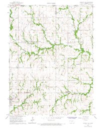
1966 Map of Hanover East
USGS Topo · Published 1967About this map
Hanover serves as the primary hub in this mid-1960s survey, situated along the Union Pacific rail lines and the banks of Cottonwood Creek. The landscape preserves a significant piece of frontier history at Hollenberg Ranch State Park, marking an era of overland travel and early settlement. Further north, the Old Indian Treaty Boundary slices diagonally across the terrain, a visible reminder of previous jurisdictional divisions. Smaller settlements such as Bremen and the cross-border community of Lanham on the Nebraska Kansas line provide a clear picture of the rural town structures during this period. The survey also captures local industry and infrastructure, from the Quarries near Hermansberg to the network of pipelines crossing through Independence and Herkimer townships, reflecting the region's evolving utility and resource management alongside established landmarks like Veterans Memorial Park.
Find a feature on this map
30 named features on this map. Tap any name to fly to it.
Don’t see what you’re looking for? This feature index may not catch every label — zoom into the map to look around manually.
Map Details
Editions of this 1966 Hanover East Map
2 editions found
Other maps of this area

1889 · Marysville
USGS Topo · 1:125,000

1894 · Marysville
USGS Topo · 1:125,000

1955 · Manhattan
USGS Topo · 1:250,000

1955 · Lincoln
USGS Topo · 1:250,000

1956 · Manhattan
USGS Topo · 1:250,000

1957 · Manhattan
USGS Topo · 1:250,000

1957 · Lincoln
USGS Topo · 1:250,000

1958 · Lincoln
USGS Topo · 1:250,000

1966 · Marysville
USGS Topo · 1:24,000

1966 · Hanover SE
USGS Topo · 1:24,000