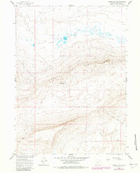
1960 Map of Hansen Lake NE
USGS Topo · Published 1981About this map
Chain Lakes Flat and the dramatic drop of the Chain Lakes Rim define this stretch of the Great Divide Basin. This 1960 survey, updated in the early 1980s, documents a high-desert landscape where water is the primary organizing force. The Chain Lakes themselves appear as a series of ephemeral basins scattered across the northern flats, while human activity is sparse, concentrated at Stratton Camp near the center of the sheet. The presence of a Well and a seasonal Spring highlights the critical nature of water sources for livestock or resource extraction in this arid environment. Transportation is limited to rugged tracks like the Riner Cutoff Road, which navigates the variable terrain between the northern plains and the more complex topography to the south. This map provides a clear record of land use in a transition zone of Sweetwater County before modern industrial shifts.
Find a feature on this map
7 named features on this map. Tap any name to fly to it.
Don’t see what you’re looking for? This feature index may not catch every label — zoom into the map to look around manually.
Map Details
Editions of this 1960 Hansen Lake NE Map
2 editions found
Other maps of this area

1954 · Rawlins
USGS Topo · 1:250,000

1955 · Casper
USGS Topo · 1:250,000

1958 · Rawlins
USGS Topo · 1:250,000

1958 · Casper
USGS Topo · 1:250,000

1960 · Battle Spring
USGS Topo · 1:24,000

1960 · Hansen Lake NE
USGS Topo · 1:24,000

1960 · Sooner Reservoir
USGS Topo · 1:24,000

1960 · Larsen Knoll
USGS Topo · 1:24,000

1960 · Hansen Lake
USGS Topo · 1:24,000

1960 · Chicken Spring
USGS Topo · 1:24,000