
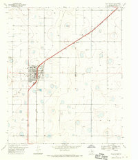
1968 Map of Happy Union
USGS Topo · Published 1970About this map
The agricultural landscape of Hale County is defined here by the sparse but vital infrastructure of the late 1960s. Happy Union sits at the heart of this survey, supported by the Happy Union Community Center and the specialized industry of the Four Hundred Cotton Gin. The terrain is characterized by the winding path of Callahan Draw, which snakes through the plains where small clusters like Snyder and Rogers 2 are noted among numerous irrigation wells.
Find a feature on this map
11 named features on this map. Tap any name to fly to it.
Don’t see what you’re looking for? This feature index may not catch every label — zoom into the map to look around manually.
Map Details
Editions of this 1968 Happy Union Map
This is the sole edition of this map. No revisions or reprints were ever made.
Other maps of this area

1954 · Lubbock
USGS Topo · 1:250,000

1954 · Plainview
USGS Topo · 1:250,000

1957 · Abernathy
USGS Topo · 1:62,500

1958 · Plainview
USGS Topo · 1:250,000

1965 · Wasson
USGS Topo · 1:24,000

1965 · Plainview
USGS Topo · 1:24,000

1968 · Barwise
USGS Topo · 1:24,000

1968 · Plainview SE
USGS Topo · 1:24,000

1968 · Julia Lake
USGS Topo · 1:24,000
1968 · Hale Center
USGS Topo · 1:24,000