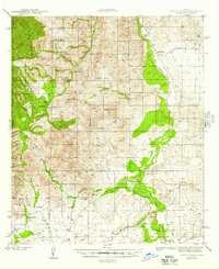
1945 Map of Happy Valley
USGS Topo · Published 1945About this map
The San Pedro River valley serves as a primary corridor for ranching and transport in the 1940s, winding through The Narrows near the small community of Pomerene. This landscape is deeply marked by a legacy of early habitation, containing both Indian Ruins and the Site of Tres Alamos, reflecting centuries of movement through the river corridor. The eastern slopes of the Rincon Mountains define the western portion of the map, where remote family operations like Watkins Ranch and Miller Ranch occupy the high ground within the Coronado National Forest.
Find a feature on this map
46 named features on this map. Tap any name to fly to it.
Don’t see what you’re looking for? This feature index may not catch every label — zoom into the map to look around manually.
Map Details
Editions of this 1945 Happy Valley Map
2 editions found

Other maps of this area

1904 · Patagonia
USGS Topo · 1:125,000

1904 · Tucson
USGS Topo · 1:125,000

1905 · Patagonia
USGS Topo · 1:125,000

1905 · Tucson
USGS Topo · 1:125,000

1915 · Benson
USGS Topo · 1:125,000

1922 · St. David
USGS Topo · 1:62,500

1926 · Whetstone
USGS Topo · 1:62,500

1943 · Benson
USGS Topo · 1:125,000

1943 · Dragoon
USGS Topo · 1:62,500

1943 · Winchester Mts.
USGS Topo · 1:62,500