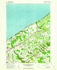
1960 Map of Harborcreek
USGS Topo · Published 1962About this map
The southern shores of Lake Erie dominate the northern landscape of this Erie County survey, where multiple creeks including Twelvemile Creek, Eightmile Creek, and Sevenmile Creek carve through the terrain toward the lake. The region's mid-century transportation and social fabric are clearly defined by the parallel tracks of the New York Central Railroad and the New York Chicago and St Louis Railroad, which support the industrial and agricultural corridors around Harborcreek. Local landmarks like the Drive-in Theater and Moorhead Air Park reflect the era's recreational growth alongside established institutions such as the Harborcreek School For Boys and the Mount St Benedict convent. Genealogists can identify numerous family-named roads and several burial sites, including St Gregory Cem, Jacob Cem, and Bohoslov Cem, nestled within the township's transition from shoreline settlements to the upland farms of Greenfield.
Find a feature on this map
56 named features on this map. Tap any name to fly to it.
Don’t see what you’re looking for? This feature index may not catch every label — zoom into the map to look around manually.
Map Details
Editions of this 1960 Harborcreek Map
3 editions found
Other maps of this area

1899 · Erie
USGS Topo · 1:62,500

1900 · Erie
USGS Topo · 1:62,500

1913 · North East
USGS Topo · 1:62,500

1915 · North East
USGS Topo · 1:62,500

1943 · North East
USGS Topo · 1:62,500

1950 · Erie
USGS Topo · 1:250,000

1957 · Erie South
USGS Topo · 1:24,000
1957 · Erie North
USGS Topo · 1:24,000

1959 · Erie
USGS Topo · 1:250,000

1960 · Buffalo
USGS Topo · 1:250,000
Featured Places
- Harborcreek Township, PA
- North East Township, PA
- Moorhead, Harborcreek Township
- Moorheadville, Harborcreek Township
- Eades Corners, PA