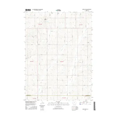
2015 Map of Hard Scratch
USGS Topo · Published 2015About this map
Hard Scratch lies at the heart of this rural landscape, situated within a rolling terrain defined by a dense network of creek valleys and section-line roads. The area is characterized by its numerous historic burial grounds, including Harris Grove Cem, Bethel Cem, and Linwood Cem, which serve as vital landmarks for genealogical research in this portion of Harrison County. The drainage pattern is complex, with Harris Grove Cr and Potato Cr carving through the loess hills, while Pigeon Cr and Neola Cr drain the eastern and southern reaches. This modern survey illustrates the enduring agricultural layout of the region, where a grid of roads like Co Rd F52 and Co Rd F58 connects scattered farmsteads and provides access to the diverse creek systems that have shaped the local topography for generations.
Find a feature on this map
60 named features on this map. Tap any name to fly to it.
Don’t see what you’re looking for? This feature index may not catch every label — zoom into the map to look around manually.
Map Details
Editions of this 2015 Hard Scratch Map
This is the sole edition of this map. No revisions or reprints were ever made.
Other maps of this area

1893 · Omaha
USGS Topo · 1:62,500

1954 · Omaha
USGS Topo · 1:250,000

1956 · Underwood
USGS Topo · 1:24,000

1956 · Neola
USGS Topo · 1:24,000

1957 · Omaha
USGS Topo · 1:250,000

1957 · Honey Creek
USGS Topo · 1:24,000

1958 · Omaha
USGS Topo · 1:250,000

1970 · Logan
USGS Topo · 1:24,000
1970 · Beebeetown
USGS Topo · 1:24,000
1978 · Hard Scratch
USGS Topo · 1:24,000