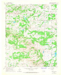
1966 Map of Harden City
USGS Topo · Published 1968About this map
Harden City and the surrounding rural landscape of Pontotoc and Coal Counties are defined by mid-century energy production and a network of natural springs. A prominent Refinery north of town and scattered Oil Wells indicate the local industrial base, while the terrain transitions into prominent elevations like Gobbler Knob and Biscuit Knob. The map traces the winding course of Clear Boggy Creek and its many tributaries, including Sheep Creek and Coal Creek, which feed into the area's complex hydrology alongside several named water sources such as Coffee Pot Spring and Wildcat Springs. Cultural landmarks for genealogists and local historians are preserved here, including the McLish Sch and the Atkins Cem situated near the primary settlement. The boundaries of the Stonewall and Brogdon districts meet along these creek beds, providing a clear record of land use and property divisions in the late 1960s.
Find a feature on this map
31 named features on this map. Tap any name to fly to it.
Don’t see what you’re looking for? This feature index may not catch every label — zoom into the map to look around manually.
Map Details
Editions of this 1966 Harden City Map
This is the sole edition of this map. No revisions or reprints were ever made.
Other maps of this area

1896 · Coalgate
USGS Topo · 1:125,000

1899 · Coalgate
USGS Topo · 1:125,000

1899 · Atoka
USGS Topo · 1:125,000

1900 · Atoka
USGS Topo · 1:125,000

1900 · Coalgate
USGS Topo · 1:125,000

1901 · Stonewall
USGS Topo · 1:125,000

1901 · Tishomingo
USGS Topo · 1:125,000

1957 · Stonewall
USGS Topo · 1:24,000

1957 · Ardmore
USGS Topo · 1:250,000

1958 · Lula
USGS Topo · 1:24,000