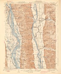
1938 Map of Hardin
USGS Topo · Published 1938About this map
Hardin and the surrounding river bottoms of Calhoun and Jersey counties are defined by the meeting of the Mississippi River and the Illinois River in this 1930s survey. The landscape is a network of backwater sloughs and landings, such as Sterling Landing and Burr Oak Ldg, which served the local river economy before modern bridge networks fully supplanted the ferry and boat landings. Evidence of early river life is visible in the placement of the Gilead Gun Club and numerous riverside settlements like Hamburg and Batchtown.
Find a feature on this map
144 named features on this map. Tap any name to fly to it.
Don’t see what you’re looking for? This feature index may not catch every label — zoom into the map to look around manually.
Map Details
Editions of this 1938 Hardin Map
2 editions found

Other maps of this area

1903 · O'Fallon
USGS Topo · 1:125,000

1924 · Roodhouse
USGS Topo · 1:62,500

1926 · Roodhouse
USGS Topo · 1:62,500

1927 · St. Charles
USGS Topo · 1:62,500

1930 · Pearl
USGS Topo · 1:62,500

1930 · Nebo
USGS Topo · 1:62,500

1930 · Hardin
USGS Topo · 1:62,500

1930 · Jerseyville
USGS Topo · 1:62,500

1931 · Brussels
USGS Topo · 1:62,500

1933 · Jerseyville
USGS Topo · 1:62,500