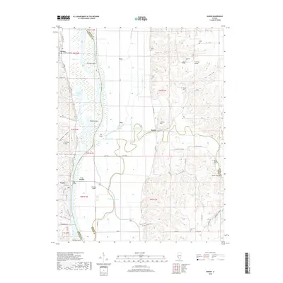
2018 Map of Hardin
USGS Topo · Published 2018About this map
The Illinois River dictates the landscape of this river-valley region, carving a wide path between the limestone bluffs of Calhoun and Greene Counties. The village of Hardin serves as a primary crossing point via the Page Bridge, connecting the narrow peninsula to East Hardin and the agricultural flats to the east. This 2018 survey reveals a terrain defined by complex drainage and island formations, including the expansive Hurricane Island and Diamond Island, alongside managed water features like White Ditch and the meandering Old Macoupin Creek. The eastern bluffs are marked by numerous family burial grounds such as Dayton Cem and Cumming Cem, while distinctive landmarks like Witachek Mound and Pea Ridge overlook the fertile bottomlands. Small settlements such as Michael and Spankey remain anchored to the local road network, which traces the foot of the hills through hollows like DeGerlia Hollow and Dayton Hollow.
Find a feature on this map
81 named features on this map. Tap any name to fly to it.
Don’t see what you’re looking for? This feature index may not catch every label — zoom into the map to look around manually.
Map Details
Editions of this 2018 Hardin Map
This is the sole edition of this map. No revisions or reprints were ever made.
Other maps of this area

1924 · Roodhouse
USGS Topo · 1:62,500

1926 · Roodhouse
USGS Topo · 1:62,500

1930 · Pearl
USGS Topo · 1:62,500

1930 · Hardin
USGS Topo · 1:62,500

1930 · Jerseyville
USGS Topo · 1:62,500

1933 · Jerseyville
USGS Topo · 1:62,500

1934 · Hardin
USGS Topo · 1:62,500

1938 · Hardin
USGS Topo · 1:62,500

1948 · Quincy
USGS Topo · 1:250,000

1950 · Pearl
USGS Topo · 1:62,500