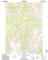
1991 Map of Hardluck Mountain
USGS Topo · Published 1997About this map
Hardluck Mountain and the high elevations of the Shoshone Plateau dominate this remote pocket of Wyoming as it was documented in the early 1990s. The landscape is defined by the high-alpine drainage systems of the South Fork Creek, East Fork Creek, and Robinson Creek, which carve deep through the Shoshone National Forest. This survey captures the boundary where the Washakie Wilderness begins, an area preserved from development and accessible primarily by trails like the Cougar Pass Trail.
Find a feature on this map
15 named features on this map. Tap any name to fly to it.
Don’t see what you’re looking for? This feature index may not catch every label — zoom into the map to look around manually.
Map Details
Editions of this 1991 Hardluck Mountain Map
This is the sole edition of this map. No revisions or reprints were ever made.
Other maps of this area

1893 · Ishawooa
USGS Topo · 1:125,000

1895 · Ishawooa
USGS Topo · 1:125,000

1899 · Ishawooa
USGS Topo · 1:125,000

1905 · Younts Peak
USGS Topo · 1:125,000

1907 · Younts Peak
USGS Topo · 1:125,000

1955 · Cody
USGS Topo · 1:250,000

1955 · Thermopolis
USGS Topo · 1:250,000

1956 · Shoshone Pass
USGS Topo · 1:24,000

1956 · Snow Lake
USGS Topo · 1:24,000

1956 · Five Pockets
USGS Topo · 1:24,000