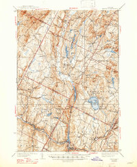
1938 Map of Hardwick
USGS Topo · Published 1947About this map
Hardwick and the surrounding villages of the Lowell Mountains are captured in this study of North-Central Vermont, based on surveys conducted in 1928 and 1934. The landscape is defined by the valley of the Lamoille River and the high-elevation settlements characteristic of the region, such as Craftsbury Common and Greensboro. Transportation in the late 1930s relied heavily on the St Johnsbury and Lake Champlain RR, which winds through the southern portion of the map near Greensboro Bend and Wolcott.
Find a feature on this map
116 named features on this map. Tap any name to fly to it.
Don’t see what you’re looking for? This feature index may not catch every label — zoom into the map to look around manually.
Map Details
Editions of this 1938 Hardwick Map
2 editions found

Other maps of this area

1919 · Lake Memphremagog
USGS Topo · 1:62,500

1919 · Montgomery
USGS Topo · 1:62,500

1919 · Montpelier
USGS Topo · 1:62,500

1920 · Montgomery
USGS Topo · 1:62,500

1920 · Derby
USGS Topo · 1:62,500

1920 · Irasburg
USGS Topo · 1:62,500

1921 · Montpelier
USGS Topo · 1:62,500

1923 · Irasburg
USGS Topo · 1:48,000

1923 · Lake Memphremagog
USGS Topo · 1:48,000

1925 · Irasburg
USGS Topo · 1:62,500