
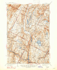
1938 Map of Hardwick
USGS Topo · Published 1938About this map
Hardwick and the surrounding Lamoille Valley are captured here in the late 1930s, showing a landscape defined by the St Johnsbury and Lake Champlain RR and the rugged topography of the Lowell Mountains. The rail line winds through the southern terrain, connecting hubs like Wolcott and Greensboro Bend to the industrial center of Hardwick. The map is particularly rich in educational history, documenting numerous rural schoolhouses including the Hazen Road Sch, Andersonville Sch, and Collinsville Sch that once served these dispersed farming communities.
Find a feature on this map
108 named features on this map. Tap any name to fly to it.
Don’t see what you’re looking for? This feature index may not catch every label — zoom into the map to look around manually.
Map Details
Editions of this 1938 Hardwick Map
2 editions found
Other maps of this area

1919 · Lake Memphremagog
USGS Topo · 1:62,500

1919 · Montgomery
USGS Topo · 1:62,500

1919 · Montpelier
USGS Topo · 1:62,500

1920 · Montgomery
USGS Topo · 1:62,500

1920 · Derby
USGS Topo · 1:62,500

1920 · Irasburg
USGS Topo · 1:62,500

1921 · Montpelier
USGS Topo · 1:62,500

1923 · Irasburg
USGS Topo · 1:48,000

1923 · Lake Memphremagog
USGS Topo · 1:48,000

1925 · Irasburg
USGS Topo · 1:62,500