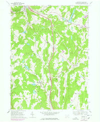
1968 Map of Harford
USGS Topo · Published 1978About this map
New Milford and the surrounding townships of Gibson and Harford characterize this portion of Susquehanna County, where the landscape is a mix of high hills and narrow valleys. The northern reach is defined by the Conrail line tracing the valley of Salt Lick Creek. Numerous crossroads settlements such as Wellmans Corners, Moxley Corners, and Kentuck Corners illustrate the historical importance of the local road network connecting rural farming communities. Water features are abundant, including Page Lake in the northeast and Tingley Lake near the western boundary, while the Fairgrounds at Harford highlights the area's agricultural heritage. Numerous quarries scattered across the map, such as those on Wolf Hill and Jones Hill, point to the region's extractive history. Notable local landmarks for genealogists include Peck Cem and Sweet Chapel, preserved here at the time of the late 1960s field check.
Find a feature on this map
42 named features on this map. Tap any name to fly to it.
Don’t see what you’re looking for? This feature index may not catch every label — zoom into the map to look around manually.
Map Details
Editions of this 1968 Harford Map
2 editions found
Other maps of this area

1892 · Dundaff
USGS Topo · 1:62,500

1932 · Susquehanna
USGS Topo · 1:62,500

1935 · Susquehanna
USGS Topo · 1:62,500

1943 · Montrose
USGS Topo · 1:62,500

1945 · Montrose
USGS Topo · 1:62,500

1946 · Tunkhannock
USGS Topo · 1:62,500
1946 · Clifford
USGS Topo · 1:24,000

1946 · Hop Bottom
USGS Topo · 1:24,000
1946 · Lenoxville
USGS Topo · 1:24,000

1947 · Hopbottom
USGS Topo · 1:24,000