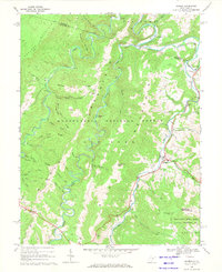
1968 Map of Harman
USGS Topo · Published 1971About this map
Harman and Jenningston anchor this late-1960s survey of the high Allegheny highlands, where the Dry Fork river carves a serpentine path through the Monongahela National Forest. The landscape is characterized by steep ridges like Shavers Mountain and Laurel Mountain, with numerous small runs and creeks feeding into the main river valley. Small clusters of settlement are concentrated along the riverbanks and mountain gaps, including Wymer, Job, and the community at Sully. Genealogists will find numerous small family cemeteries, simply marked Cem, scattered across the slopes and valley floors, often near small rural landmarks like the Riverside Ch. The southern portion of the map includes part of the Spruce Knob-Seneca Rocks National Recreation Area, reflecting the area's transition toward protected federal lands while maintaining its character as a working mountain landscape with active Gas Wells and a Quarry.
Find a feature on this map
51 named features on this map. Tap any name to fly to it.
Don’t see what you’re looking for? This feature index may not catch every label — zoom into the map to look around manually.
Map Details
Editions of this 1968 Harman Map
3 editions found
Other maps of this area

1886 · St. George
USGS Topo · 1:125,000

1889 · Beverly
USGS Topo · 1:125,000

1891 · St. George
USGS Topo · 1:125,000

1892 · Beverly
USGS Topo · 1:125,000

1892 · Franklin
USGS Topo · 1:125,000

1895 · Piedmont
USGS Topo · 1:125,000

1896 · Franklin
USGS Topo · 1:125,000

1908 · Parsons
USGS Topo · 1:62,500

1916 · Davis
USGS Topo · 1:48,000

1918 · Davis
USGS Topo · 1:62,500