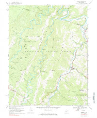
1968 Map of Harman
USGS Topo · Published 1984About this map
Harman stands at the confluence of Dry Fork and Horsecamp Run, serving as a central point in this rugged portion of Monongahela National Forest. The landscape is dominated by parallel ridges like Shavers Mountain, Middle Mountain, and Rich Mountain, which channel numerous waterways through steep valleys. Small settlements and mountain hamlets such as Sully, Wymer, and Jenningston are linked by winding roads like U.S. 33 and W. Va. 32. Local genealogy is preserved in several rural burial grounds, including Kerns Cem and Spruce Run Cem. The map reveals a remote geography of deep hollows and named ridges like Panther Camp Ridge and Brushy Ridge, where land use is defined by isolated Gas Wells, a Quarry, and the winding paths of Glady Fork and Laurel Fork.
Find a feature on this map
61 named features on this map. Tap any name to fly to it.
Don’t see what you’re looking for? This feature index may not catch every label — zoom into the map to look around manually.
Map Details
Editions of this 1968 Harman Map
3 editions found
Other maps of this area

1886 · St. George
USGS Topo · 1:125,000

1889 · Beverly
USGS Topo · 1:125,000

1891 · St. George
USGS Topo · 1:125,000

1892 · Beverly
USGS Topo · 1:125,000

1892 · Franklin
USGS Topo · 1:125,000

1895 · Piedmont
USGS Topo · 1:125,000

1896 · Franklin
USGS Topo · 1:125,000

1908 · Parsons
USGS Topo · 1:62,500

1916 · Davis
USGS Topo · 1:48,000

1918 · Davis
USGS Topo · 1:62,500