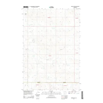
2014 Map of Harmon Butte
USGS Topo · Published 2014About this map
Harmon Butte stands as a prominent landmark in this prairie landscape along the southern border of Fallon County. The terrain is defined by a dense network of intermittent drainage, where the headwaters of O'Fallon Cr and its tributaries, such as Lame Jones Cr and Ash Cr, have carved intricate patterns into the high plains. The area serves as a watershed divide, with Milk Cr and the S Fork Milk Cr branching across the eastern half of the quadrangle. Human presence is marked primarily by section lines and gravel routes including Willard Rd W and Ismay Rd S, which facilitate travel across this open rangeland. The southern edge of the map tracks the political boundary where Fallon County meets Carter County, illustrating the remote and expansive nature of Montana’s southeastern corner.
Find a feature on this map
19 named features on this map. Tap any name to fly to it.
Don’t see what you’re looking for? This feature index may not catch every label — zoom into the map to look around manually.
Map Details
Editions of this 2014 Harmon Butte Map
This is the sole edition of this map. No revisions or reprints were ever made.
Other maps of this area

1953 · Miles City
USGS Topo · 1:250,000

1957 · Miles City
USGS Topo · 1:250,000

1958 · Miles City
USGS Topo · 1:250,000

1981 · Baker
USGS Topo · 1:100,000
1981 · Skunk Creek
USGS Topo · 1:24,000

1981 · Harmon Butte
USGS Topo · 1:24,000

1981 · Nelson Butte
USGS Topo · 1:24,000

1981 · Little Pine Creek
USGS Topo · 1:24,000

1981 · Bracket Butte SE
USGS Topo · 1:24,000

1981 · Seven-Up Butte
USGS Topo · 1:24,000