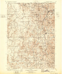
1901 Map of Harney Peak
USGS Topo · Published 1932About this map
Harney Peak towers over a landscape defined by turn-of-the-century extraction and ranching within the Black Hills National Forest. The eastern portion of the map is densely populated with mining operations including the Storm Hill Tin Lode Mine and the Accidental Mine and Mill, reflecting the region's intense industrial activity following the gold and tin rushes. The settlement of Hill City serves as a central hub, while the Sylvan Lake Hotel and the newly established Jewel Cave National Monument indicate the early emergence of the area as a destination for geological tourism.
Find a feature on this map
116 named features on this map. Tap any name to fly to it.
Don’t see what you’re looking for? This feature index may not catch every label — zoom into the map to look around manually.
Map Details
Editions of this 1901 Harney Peak Map
4 editions found

Other maps of this area

1893 · Rapid
USGS Topo · 1:125,000

1894 · Deadwood
USGS Topo · 1:125,000

1894 · Hermosa
USGS Topo · 1:125,000

1896 · Oelrichs
USGS Topo · 1:125,000

1896 · Harney Peak
USGS Topo · 1:125,000

1898 · Sundance
USGS Topo · 1:125,000

1898 · Rapid
USGS Topo · 1:125,000

1899 · Newcastle
USGS Topo · 1:125,000

1900 · Oelrichs
USGS Topo · 1:125,000

1901 · Hermosa
USGS Topo · 1:125,000