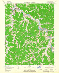
1954 Map of Harold
USGS Topo · Published 1967About this map
The Levisa Fork carves a winding path through this corner of Floyd County, serving as the primary corridor for both the Chesapeake and Ohio railroad and localized settlement in the mid-1950s. Communities like Allen City and Betsy Layne are anchored to the riverbanks, where the valley floor provides rare level ground for development. At Beaver Junction, the rail lines and waterways converge, highlighting the region's historical role as a transit hub for eastern Kentucky's industrial resources.
Find a feature on this map
81 named features on this map. Tap any name to fly to it.
Don’t see what you’re looking for? This feature index may not catch every label — zoom into the map to look around manually.
Map Details
Editions of this 1954 Harold Map
2 editions found
Other maps of this area

1886 · Prestonsburg
USGS Topo · 1:125,000

1890 · Whitesburg
USGS Topo · 1:125,000

1892 · Whitesburg
USGS Topo · 1:125,000

1892 · Prestonsburg
USGS Topo · 1:125,000

1912 · Hindman
USGS Topo · 1:48,000

1914 · Laynesville
USGS Topo · 1:48,000

1914 · Vergie
USGS Topo · 1:48,000

1915 · Prestonsburg
USGS Topo · 1:62,500

1915 · Hindman
USGS Topo · 1:62,500

1916 · Harold
USGS Topo · 1:62,500