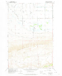
1958 Map of Harrah SE
USGS Topo · Published 1975About this map
The dramatic rise of Toppenish Ridge dominates the southern half of this landscape, marking a sharp transition between the irrigated valley floor and the high, broken country to the south. In the late 1950s, this area of Yakima County was defined by its sophisticated water management system, seen in the network of the Piute Lateral, East Island Lateral, and the Mud Lake Drain. This infrastructure supported agricultural development along Toppenish Creek, where a Diversion Dam and Powerhouse controlled the flow near Mud Lake.
Find a feature on this map
27 named features on this map. Tap any name to fly to it.
Don’t see what you’re looking for? This feature index may not catch every label — zoom into the map to look around manually.
Map Details
Editions of this 1958 Harrah SE Map
2 editions found
Other maps of this area

1910 · Zillah
USGS Topo · 1:125,000

1937 · White Swan
USGS Topo · 1:125,000

1950 · Yakima
USGS Topo · 1:250,000

1958 · Toppenish SW
USGS Topo · 1:24,000

1958 · Toppenish Mtn.
USGS Topo · 1:24,000

1958 · Harrah
USGS Topo · 1:24,000

1958 · White Swan
USGS Topo · 1:24,000

1958 · Harrah SE
USGS Topo · 1:24,000
1958 · Wapato
USGS Topo · 1:24,000

1958 · Yakima
USGS Topo · 1:250,000