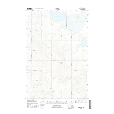
2014 Map of Harriet Lake
USGS Topo · Published 2014About this map
Harriet Lake dominates the northern reaches of this landscape in Burleigh County, North Dakota. The area is defined by a strictly organized section-line road network, where long east-west thoroughfares like 188th Ave NE and 279th Ave NE intersect with north-south routes including 340th St NE and 392nd St NE. This geometric grid reflects the systematic agrarian settlement of the northern plains, where property boundaries and travel routes were dictated by the Public Land Survey System. The terrain around the lake is characterized by numerous small depressions and seasonal wetlands typical of the prairie pothole region, influencing the path of local roads such as 253rd Ave NE and 366th St NE as they navigate the subtle elevation changes of the glaciated plains.
Find a feature on this map
16 named features on this map. Tap any name to fly to it.
Don’t see what you’re looking for? This feature index may not catch every label — zoom into the map to look around manually.
Map Details
Editions of this 2014 Harriet Lake Map
This is the sole edition of this map. No revisions or reprints were ever made.
Other maps of this area

1951 · McKenzie
USGS Topo · 1:62,500

1951 · Driscoll
USGS Topo · 1:62,500

1954 · Bismarck
USGS Topo · 1:250,000

1954 · McClusky
USGS Topo · 1:250,000

1958 · Bismarck
USGS Topo · 1:250,000

1958 · McClusky
USGS Topo · 1:250,000

1975 · Sibley Butte
USGS Topo · 1:24,000

1975 · Wing SE
USGS Topo · 1:24,000
1975 · Stony Slough
USGS Topo · 1:24,000
1975 · Clear Lake
USGS Topo · 1:24,000