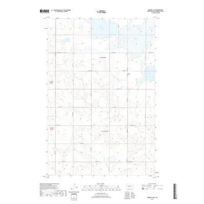
2017 Map of Harriet Lake
USGS Topo · Published 2017About this map
Harriet Lake and its surrounding wetlands dominate the northern reaches of this Burleigh County landscape. The terrain is defined by the Public Land Survey System divisions of T142n R75w and T141n R75w, where a regular grid of county roads such as 340th St NE and 392nd St NE segments the prairie. For genealogists and local historians, the Mennonite Zion Cem serves as a significant cultural landmark, situated near the center of the eastern half of the map. This 2017 survey reflects the persistent rural character of the North Dakota plains, where small cemeteries and isolated water bodies remain the primary anchors for local history and land ownership records.
Find a feature on this map
13 named features on this map. Tap any name to fly to it.
Don’t see what you’re looking for? This feature index may not catch every label — zoom into the map to look around manually.
Map Details
Editions of this 2017 Harriet Lake Map
This is the sole edition of this map. No revisions or reprints were ever made.
Other maps of this area

1951 · McKenzie
USGS Topo · 1:62,500

1951 · Driscoll
USGS Topo · 1:62,500

1954 · Bismarck
USGS Topo · 1:250,000

1954 · McClusky
USGS Topo · 1:250,000

1958 · Bismarck
USGS Topo · 1:250,000

1958 · McClusky
USGS Topo · 1:250,000

1975 · Sibley Butte
USGS Topo · 1:24,000

1975 · Wing SE
USGS Topo · 1:24,000
1975 · Stony Slough
USGS Topo · 1:24,000
1975 · Clear Lake
USGS Topo · 1:24,000