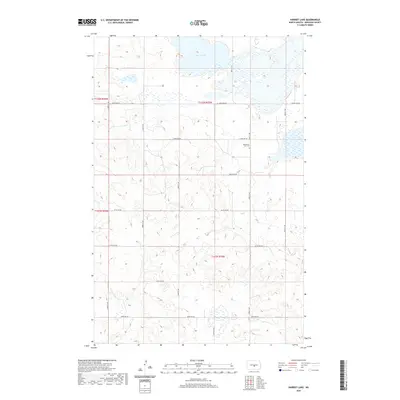
2020 Map of Harriet Lake
USGS Topo · Published 2020About this map
Harriet Lake and its surrounding wetlands dominate the northern landscape of this Burleigh County region, a terrain shaped by the glacial prairie pothole system. This modern 2020 survey illustrates the sparse, grid-based agricultural development of the High Plains, where long section roads such as 266th Ave NE and 240th Ave NE bisect the open country. For those tracing local history or family ties, the Mennonite Zion Cem stands as a significant cultural landmark in the northeastern portion of the map, located near the intersection of 253rd Ave NE. The map provides a clear record of the current property boundaries and the established road network that serves the isolated farmsteads and rural townships of North Dakota.
Find a feature on this map
13 named features on this map. Tap any name to fly to it.
Don’t see what you’re looking for? This feature index may not catch every label — zoom into the map to look around manually.
Map Details
Editions of this 2020 Harriet Lake Map
This is the sole edition of this map. No revisions or reprints were ever made.
Other maps of this area

1951 · McKenzie
USGS Topo · 1:62,500

1951 · Driscoll
USGS Topo · 1:62,500

1954 · Bismarck
USGS Topo · 1:250,000

1954 · McClusky
USGS Topo · 1:250,000

1958 · Bismarck
USGS Topo · 1:250,000

1958 · McClusky
USGS Topo · 1:250,000

1975 · Sibley Butte
USGS Topo · 1:24,000

1975 · Wing SE
USGS Topo · 1:24,000
1975 · Stony Slough
USGS Topo · 1:24,000
1975 · Clear Lake
USGS Topo · 1:24,000