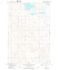
1979 Map of Harriet Lake
USGS Topo · Published 1979About this map
Harriet Lake and its surrounding wetlands define this prairie landscape on the border of Wing and Lein townships. In the late 1970s, much of the northern terrain was dedicated to conservation, including the Arena State Game Management Area and a National Waterfowl Production Area. These protected spaces reflect a shift toward environmental management in Burleigh County, contrasting with the scattered agricultural activity indicated by numerous wells and localized Gravel Pits. Local civic life and history are anchored by the Zion Ch and its adjacent Cem, located near a central Townhall. The map reveals a sparsely populated region where section lines dictate the road network, connecting isolated farmsteads and rural community centers in the heart of the North Dakota plains.
Find a feature on this map
10 named features on this map. Tap any name to fly to it.
Don’t see what you’re looking for? This feature index may not catch every label — zoom into the map to look around manually.
Map Details
Editions of this 1979 Harriet Lake Map
This is the sole edition of this map. No revisions or reprints were ever made.
Other maps of this area

1951 · McKenzie
USGS Topo · 1:62,500

1951 · Driscoll
USGS Topo · 1:62,500

1954 · Bismarck
USGS Topo · 1:250,000

1954 · McClusky
USGS Topo · 1:250,000

1958 · Bismarck
USGS Topo · 1:250,000

1958 · McClusky
USGS Topo · 1:250,000

1975 · Sibley Butte
USGS Topo · 1:24,000

1975 · Wing SE
USGS Topo · 1:24,000
1975 · Stony Slough
USGS Topo · 1:24,000
1975 · Clear Lake
USGS Topo · 1:24,000