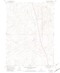
1968 Map of Harris Canyon
USGS Topo · Published 1983About this map
The Union Pacific railroad line cuts a straight north-south path through this high-elevation landscape of Elko County, serving as the primary industrial artery through the eastern Nevada basin and range. The high desert terrain is defined by a network of seasonal watercourses and drainage systems, including the prominent Harris Canyon which gives the quadrangle its name. Water management is a central theme here, evidenced by features such as the Harris Canyon Dam and several isolated watering points like Dry Basin Well and Well 5618. Small clusters of human activity are sparse, centered on the location at Shores and various resource extraction sites. Local relief is provided by landmarks such as Rocky Peak and the expansive Eagle Flat. The map also documents a legacy of land use through scattered Gravel Pits, Mud Springs, and the remote Bull Camp located in the southern draws.
Find a feature on this map
24 named features on this map. Tap any name to fly to it.
Don’t see what you’re looking for? This feature index may not catch every label — zoom into the map to look around manually.
Map Details
Editions of this 1968 Harris Canyon Map
2 editions found
Other maps of this area

1955 · Wells
USGS Topo · 1:250,000

1958 · Wells
USGS Topo · 1:250,000

1961 · Wells
USGS Topo · 1:250,000

1968 · Wilkins
USGS Topo · 1:24,000

1968 · Knoll Mountain
USGS Topo · 1:24,000

1968 · Hubbard Basin
USGS Topo · 1:24,000

1968 · Henry
USGS Topo · 1:24,000

1968 · Wine Cup Ranch
USGS Topo · 1:24,000

1968 · Blanchard Mtn
USGS Topo · 1:24,000
1968 · Loomis Mtn
USGS Topo · 1:24,000