
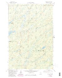
1981 Map of Harris Lake
USGS Topo · Published 1985About this map
Superior National Forest and Cloquet Valley State Forest dominate this section of St. Louis County, where the landscape is defined by an intricate network of waterways and timber. The Whiteface Reservoir and Linwood Lake are central hydrologic features, fed by a complex drainage system including the North Branch Whiteface River and the South Branch Whiteface River. This 1980s-era survey illustrates the area's transition into a managed wilderness and recreation zone, with numerous Gravel Pits indicating local extraction for forest road maintenance. Notable recreational infrastructure is present in the form of a designated Snowmobile Trail and Hagstrom Road. Further south, the W Br Cloquet R winds through the state forest, while smaller tributaries like Porcupine Creek and Skivven Creek carve through the wooded terrain.
Find a feature on this map
21 named features on this map. Tap any name to fly to it.
Don’t see what you’re looking for? This feature index may not catch every label — zoom into the map to look around manually.
Map Details
Editions of this 1981 Harris Lake Map
3 editions found

Other maps of this area

1954 · Two Harbors
USGS Topo · 1:250,000

1954 · Hibbing
USGS Topo · 1:250,000

1956 · Pequaywan Lake
USGS Topo · 1:24,000

1957 · Two Harbors
USGS Topo · 1:250,000

1957 · Hibbing
USGS Topo · 1:250,000

1957 · Brimson
USGS Topo · 1:62,500

1957 · Markham
USGS Topo · 1:62,500

1957 · Comstock Lake
USGS Topo · 1:24,000
1957 · Boulder Lake Reservoir NE
USGS Topo · 1:24,000

1958 · Hibbing
USGS Topo · 1:250,000