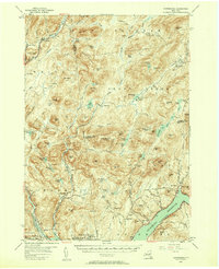
1954 Map of Harrisburg
USGS Topo · Published 1958About this map
Hope Falls and the surrounding Adirondack wilderness define this mid-century landscape where Hamilton, Warren, Saratoga, and Fulton counties meet. The southern portion of the map is dominated by the Sacandaga Reservoir, a significant man-made feature that altered the local topography. This era reflects a transition where old trails like the Oregon Trail and Madison Trail remained critical for navigating the dense forests and numerous vlies, such as Taylor Vly and Masher Vly.
Find a feature on this map
103 named features on this map. Tap any name to fly to it.
Don’t see what you’re looking for? This feature index may not catch every label — zoom into the map to look around manually.
Map Details
Editions of this 1954 Harrisburg Map
5 editions found

Other maps of this area

1895 · North Creek
USGS Topo · 1:62,500

1897 · North Creek
USGS Topo · 1:62,500

1898 · Thirteenth Lake
USGS Topo · 1:62,500

1899 · Indian Lake
USGS Topo · 1:62,500

1899 · Broadalbin
USGS Topo · 1:62,500

1902 · Broadalbin
USGS Topo · 1:62,500

1902 · Saratoga
USGS Topo · 1:62,500

1902 · Indian Lake
USGS Topo · 1:62,500

1903 · Luzerne
USGS Topo · 1:62,500

1903 · Gloversville
USGS Topo · 1:62,500