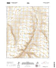
2017 Map of Harrison Bay A-1 SE
USGS Topo · Published 2017About this map
The Miluveach River winds across this Arctic landscape, its meandering channel defining the central geography of this North Slope region. Located within the North Slope Borough, the map details a territory governed by the Public Land Survey System, specifically covering portions of T9n R7e, T9n R8e, T8n R7e, and T8n R8e. This area is characterized by low-lying wetlands and a complex network of thaw lakes and drainage patterns typical of the coastal plain environment. The lack of man-made structures or improved roads highlights the remote nature of this terrain, where the water's path remains the primary landmark for navigation and environmental study.
Find a feature on this map
5 named features on this map. Tap any name to fly to it.
Don’t see what you’re looking for? This feature index may not catch every label — zoom into the map to look around manually.
Map Details
Editions of this 2017 Harrison Bay A-1 SE Map
This is the sole edition of this map. No revisions or reprints were ever made.
Other maps of this area

1951 · Harrison Bay
USGS Topo · 1:250,000

1951 · Beechey Point
USGS Topo · 1:250,000

1951 · Sagavanirktok D-5
USGS Topo · 1:250,000

1952 · Umiat
USGS Topo · 1:250,000

1955 · Harrison Bay
USGS Topo · 1:250,000

1955 · Beechey Point
USGS Topo · 1:250,000

1955 · Beechey Point A-5
USGS Topo · 1:63,360
1955 · Sagavanirktok D-5
USGS Topo · 1:63,360
1955 · Harrison Bay A-1
USGS Topo · 1:63,360
1955 · Umiat D-1
USGS Topo · 1:63,360